
Collaboration & Research
Contact us to include your collaborations & research here.
Post-doctoral or PhD researchers
Organization KIT / IMK-IFU
Deadline Friday, March 31, 2023
Start Date Monday, May 15, 2023
Overview
We seek to appoint up to 5 quantitative Environmental Scientists on the topic of Land Use & Ecosystem Change as either post-doctoral researchers or PhD students. The successful candidates will undertake research on the integrated impacts of societal, environmental and policy change on land use and ecosystems at large spatial scales (national to global), including contributing to the LandSyMM modelling framework (https://landsymm.earth/). We would like you to join us to work on one or more of the following topics and associated research questions.
Modelling land use change in Europe using the CRAFTY agent-based models
Identifying the potential for ecosystem restoration, including rewilding, in Europe.
Reconstructing past land management change, and environmental impacts at the global scale.
Exploring the consequences of disruptive technology scenarios for the global food system.
Evaluating the impact of international trade and environmental policy on land use and ecosystems.
The successful applicants will be funded through two EU-funded research projects (see annex) and the Helmholtz Association Excellence Recruiting Initiative, which supports the Land Use Change & Climate (LUCC) Research Group (https://landchange.imk-ifu.kit.edu/) of the Karlsruhe Institute of Technology (KIT). The positions will be located at KIT’s attractive ‘Campus Alpin’ in Garmisch-Partenkirchen, Germany.
Qualifications
You will have a PhD or Master’s degree in a relevant discipline such as environmental sciences, geo-ecology, geography, spatial ecology, ecological economics, computational social sciences, mathematics and informatics. You will also have skills in one or more of the following:
quantitative environmental modelling;
computer programming (e.g., Java, Python, C++);
the analysis of large-scale datasets in the environmental sciences;
scenario analysis, environmental policy analysis, statistical analysis and ecosystem assessment.
Applications
Applications should be sent by email to Sylvia Kratz (sylvia.kratz@kit.edu) by Friday 31 March 2023, quoting the reference, 5MR2023. Applications should be submitted within a single PDF document that includes your CV, publications list (with citations), a short (1-2 page) letter of motivation and contact details for 2 referees. The motivation letter should clearly state a) whether you are applying for a post-doctoral or PhD position, b) your skills and experience in land use & ecosystem change, and c) how your research interests relate to the topics given above. Please also indicate where you heard about this job opportunity. Applications that are incomplete or do not address these criteria will not be considered.
Interviews will be held remotely on 19-21 April 2023.
KIT strives to achieve gender equality at all levels of employment and we particularly encourage applications from women. With appropriate qualifications, applications from persons with handicaps are treated preferentially.
Fellowship: Kansas State University
Fellow (Post Doc Res)
Organization: Kansas State University
Deadline Monday, March 13, 2023
Start Date Saturday, July 1, 2023
Learn more and apply
Download the full job description
Description: The Department of Agricultural Economics at Kansas State University seeks to fill a 12-month postdoctoral, full-time, non-tenure track appointment in Agricultural Economics. This will be an annual appointment, renewable for up to two years. The expected starting date is July 1st, 2023. The Department has a reputation for excellence in all three functions of the University’s land grant mission (teaching, research, and extension).
The candidate will lead the creation of a new spatially explicit global database of subnational land use at the grid-cell level that can be aggregated to different climatic and/or biogeographical regions to allow for greater spatial flexibility in the analysis of policies that affect global land use. The new land use dataset will be coupled with a dataset of soil carbon, biomass, and land-cover-specific emission factors that will be developed by collaborators at the University of Wisconsin-Madison. Both the newly created land use dataset and associated emission factors will be embedded in an applied general equilibrium model based on the GTAP-AEZ framework. The candidate is expected to lead research analyzing the effects of relevant policies (e.g., supply chain or international trade policies) with potential effects on global land use and associated greenhouse gas emissions. The candidate will work under the supervision of Prof. Nelson Villoria (nvilloria@ksu.edu), and in close collaboration with researchers at the USDA Economic Research Service and the University of Wisconsin-Madison.
Job: Researcher in integrated modeling of environmental impacts
Researcher in integrated modeling of environmental impacts
Organization International Institute for Applied System Analysis (IIASA)
Deadline Friday, March 10, 2023
Start Date Monday, May 1, 2023
THE POSITION
IBF is offering a research position in the integrated modeling of resource use and environmental impacts to advance the understanding and development of land and water use systems compatible with the Sustainable Development Goals (SDGs) and planetary boundaries. Within a vibrant multi-disciplinary research team, the successful candidate will consolidate and expand the representation in the iBIOM integrated modeling platform around the GLOBIOM model of the environmental impacts (e.g., GHG, nutrient and water cycles, biodiversity), safe boundaries (e.g., level of pressures compatible with planetary boundaries) and contributions to people (e.g., material, regulation and non-material contributions) associated with the management of the land and freshwater resources for the agriculture, forestry, bioenergy and aquaculture sectors.
MAIN TASKS AND RESPONSIBILITIES
Employ external datasets and outputs of (and occasionally run and contribute to the development of) process-based and statistical models to:
Contribute to methodological and structural development of the GLOBIOM model and the iBIOM integrated modeling platform, through interfacing biophysical, biodiversity and economic models
Apply the GLOBIOM and iBIOM integrated modeling platform in the context of research and policy projects
Publish relevant results in peer-reviewed journals and participate in scientific conferences and workshops
Contribute to project deliverables, reports, stakeholder communication.
Collaboration: US NSF/GEO - UK NERC
Rolling applications, up to $300,000
The Directorate for Geosciences (GEO) of the National Science Foundation (NSF) and the Natural Environment Research Council (NERC) of the Research Councils UK (RCUK) are pleased to announce an NSF/GEO-NERC lead agency opportunity. The goal of this opportunity is to reduce some of the current barriers to working internationally. Through a lead agency model, GEO and NERC will address these issues by allowing US and UK researchers to submit a single collaborative proposal that will undergo a single review process. Proposals centered on Atmospheric and Geospace Sciences, Earth Sciences, Ocean Sciences, and Polar Programs are welcomed.
SURVEY: Policy instruments for sustainable peri-urban landscapes
Several GLP Members are asking for the community's help in answering their survey related to governance of peri-urban landscapes (PULs). The objective is to investigate what policy instruments are available to address the sustainability challenges of PULs, how they have been implemented, and with what results.
The survey will remain open until the middle of September.
Take the survey here.

Call for Papers: Modelling of temporal or spatial scales in land use dynamics
SESMO (Socio-Environmental Systems Modelling www.sesmo.org) is an open access journal with the objective to progress our understanding, learning and decision making on major socio-environmental issues using advances in model-grounded processes that engage with institutional and governance contexts, cross-sectoral and scale challenges, and stakeholder perspectives.
SESMO is launching a call for a thematic issue on large-scale behavioural models of land use change. We are calling for contributions of scholars intending to present their latest research results on this topic.

Call for Papers : Remote Sensing - Special Issue "Analysis of Land Cover Change within Semiarid Environments Using Satellite Imagery & GIS
The landscape is continually changing across the globe. Some of these changes may be considered advantageous, while others are a detriment to ecosystem health, water and air quality, wildlife habitat, and the socioeconomic services provided by the affected landscape. There are numerous drivers of land cover change, including the proximate drivers of fire, invasive plants, and herbivory along with the overarching and ultimate driver; the influence of the anthropic forces of land management.
Savanna ecosystems occupy 20% of the world’s land surface and provide numerous important socioeconomic services to our communities. These ecosystems, like so many others across the globe, are a witness to tremendous land cover change, including those noted above, as well as a transition from natural to agrarian or urban systems.
I invite you to participate in this very Special Edition of Remote Sensing and share your land cover change research in savanna ecosystems.
Guest Editor Keith Weber
Keywords: Land cover change, Savanna, Savannah, Remote sensing, Fire, Invasive plants, Herbivory, Land management, Urbanization

Call for papers: "Special Issue "Remote Sensing of Land Use/Cover Changes Using Very High Resolution Satellite Data"
This Special Issue invites articles that highlight the integration of VHR data with novel algorithms, e.g., using Machine Learning approaches, which could include deep learning and data mining for LU/CC mapping, monitoring and impact assessment studies, such as the following:
Forest disturbance mapping and changes
Agricultural monitoring that would include remote sensing of crop growth stages, crop production, farming practices, and impacts on water/energy balance
Urbanization and associated impacts (urban heat island effect, air and water pollution, etc.)
Monitoring fires, biomass burning, and its impacts
Mapping and monitoring of land management practices, disturbances, and interactions
New tools and methods for fusing VHR and moderate resolution data
The current call for papers is targeting NASA-funded researchers who have been using VHR data in LU/CC research and applications. The issue is open for non-NASA (and non-US) researchers if the critical mass of accepted papers is not reached.
More information…

Research Fellowship - Karlsruhe Institute of Technology
Research fellowship in modelling terrestrial ecosystems and biodiversity responses to environmental and socioeconomic changes (up to 24 months)
Start Date: July 1, 2021
Download the full position description
Are you an excellent early career researcher from abroad, interested in obtaining a Humboldt Research Fellowship to perform research in Germany? Do your research interests include modelling of (large regional/global) land ecosystem processes, climate change, land-use change and socio-ecological modelling? Do you have skills in the analysis of large data sets, modelling or code development?

NSF Atmospheric & Geospace Sciences: Climate & Large-scale Dynamics
Division of Atmospheric and Geospace Sciences
Climate and Large-Scale Dynamics (CLD)
Rolling applications, amounts vary $40,000-1,000,000
The goals of the Program are to: (i) advance knowledge about the processes that force and regulate the atmosphere’s synoptic and planetary circulation, weather and climate, and (ii) sustain the pool of human resources required for excellence in synoptic and global atmospheric dynamics and climate research.
Research topics include theoretical, observational and modeling studies of the general circulation of the stratosphere and troposphere; synoptic scale weather phenomena; processes that govern climate; the causes of climate variability and change; methods to predict climate variations; extended weather and climate predictability; development and testing of parameterization of physical processes; numerical methods for use in large-scale weather and climate models; the assembly and analysis of instrumental and/or modeled weather and climate data; data assimilation studies; development and use of climate models to diagnose and simulate climate and its variations and change.
Some Climate and Large Scale Dynamics (CLD) proposals address multidisciplinary problems and are often co-reviewed with other NSF programs, some of which, unlike CLD, use panels in addition to mail reviewers, and thus have target dates or deadlines. Proposed research that spans in substantive ways topics appropriate to programs in other divisions at NSF, e.g., ocean sciences, ecological sciences, hydrological sciences, geography and regional sciences, applied math and statistics, etc., must be submitted at times consistent with target dates or deadlines established by those programs.

Global Land Programme - New Working Groups
Agricultural Land Abandonment as a Global Land-use Change Phenomenon
The main goal of this Working Group is to understand better the patterns, underling causes, and implications of land abandonment in the connection to sustainable land use. More information…
Global Dryland Social-Ecological Systems
The purpose of this Working Group is to understand the dynamics, structure, functions and services of dryland SES, which is critical for addressing the vulnerability, resilience, livelihoods and sustainability of humans in the context of SDGs. More information…
Remittance Dynamics and Land Change
The primary goal of this Working Group is to gather together a critical mass of interested land system scientists to examine the multiple facets of remittance dynamics and change in land systems throughout the world. More information…

Research: Interdependent Dynamics of Food, Energy and Water in Kazakhstan and Mongolia: Connecting LULCC to the Transitional Socioecological Systems (LCLUC)
This study is proposed to examine the interconnections of food, energy and water (FEW), as well as their interdependent dynamics under the rapid changes in climate and intensified land use in Kazakhstan (KaZ) and Mongolia (MG) over a 40-year period (1981-2020). We will apply the concept, principles and methods of socioeconomic-ecological systems to guide our research at three hierarchical levels: local, provincial and national. Net primary production, albedo, and evapotranspiration will be used as the key indicators for food production, radiation energy, and water balance, respectively, of the rangelands that support continued increases in economies, livestock, agriculture, and human development.

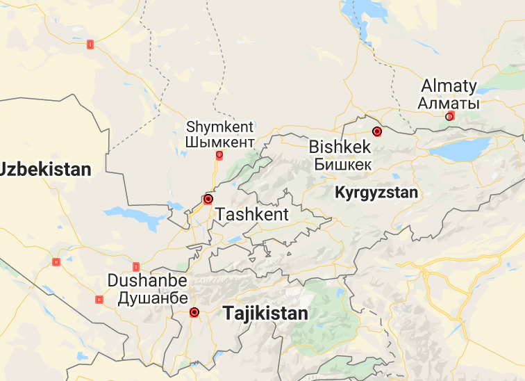
Research: Atmospheric Teleconnections and Anthropogenic Telecouplings Drive Land Change in Central Asian Highlands (LCLUC)
Our LCLUC project builds on our prior research findings in the region support to advance understanding of the land change occurring in the rural highlands of montane Central Asia due both to changing environmental conditions and socioeconomic processes. Our study region encompasses all highland pastures between 1800 and 4800 m amsl in the Tien Shan and Pamir mountain ranges in Central Asia. This area includes much of Kyrgyzstan (92.3K km2) and Tajikistan (56.3K km2), and smaller portions of Kazakhstan (15.1K km2), Uzbekistan (12.6K km2), and Turkmenistan (158 km2). The project’s three key questions are: (1) How, where, and when do changes in environmental drivers affect pasture productivity and land degradation? (2) How, where, and when do environmental changes (e.g., changing snow season, natural disasters, pasture degradation, risk perception) trigger/drive migration? and (3) How, where, and when do migration and remittances increase risk of pasture & land degradation?
Research: Rapid Urbanization, Changing Croplands and Increasing Population Health Vulnerabilities in the China-Central Asia-West Asia Economic Corridor (LCLUC)
We propose to investigate the growth of cities and the dryland system land use transitions in Central Asia as a result of China’s Belt and Road initiative, a large planned series of Chinese investments in the region. Our research questions are as follows:
1. How have past investment and infrastructure developments (1995-2014) led to varying patterns of urbanization, resource, and population flows, and changing land use across Central Asian cities? How will the ongoing development of the BRI, and/or proximity to BRI connected cities impact the emerging urban ecosystems, microbial and human ecologies in these areas going forward (2014-2020)?
2. What are the economic and social effects of BRI investments on urban and peri-urban areas in Central Asia? How far improved is connectivity between cities, and what impact is this likely to have on patterns of land use, zoonotic disease risks, agriculture, and economic development?
3. What new infectious disease risks exist and how will they impact economic growth? To what extent is BRI-connectivity creating uneven patterns of rural-urban development and how might this impact urbanization, growth, and population health in the future?
Research: Monitoring Abandoned Agriculture, Fallow Fields, and Grasslands with Landsat and Sentinel-2 (LCLUC)
Our main goal is to monitor abandoned agriculture, fallow fields, and grasslands with combined satellite images from Landsat and Sentinel-2. Our objectives are: 1) Analyze Landsat and Sentinel-2 data from single years to classify active agriculture, hayfields, and both non-woody and woody herbaceous cover; 2) analyze Landsat data from multiple years to classify a) non-woody herbaceous cover into non-woody abandoned agriculture, fallow fields, and grasslands, b) woody herbaceous cover into woody abandoned agriculture and permanent grasslands, and c) active agriculture in permanent agriculture and areas that were re-cultivated; 3) conduct a rigorous accuracy assessment and uncertainty analyses, and evaluate the robustness of the developed algorithms and their potential for operational use in the future, and 4) explore the effects of a) temperature data from TIRS, b) texture information, and c) fire detection on the mapping accuracy of abandoned agriculture.